Cerrado-Amazônia
TOCANTINS
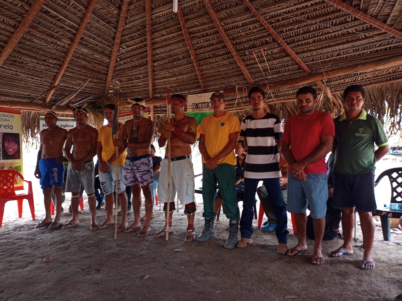
The Krahô-Kanela people are made up of about 160 indigenous persons whose territory has not yet been fully recognized[1]. Part of the group lives in the Lankraré and Catàmjê village, located between the Formoso and Javaés rivers, in the municipality of Lagoa da Confusão, Tocantins state. In addition to living in a limited area, the Krahô-Kanela face a difficult reality caused by deforestation, fires, and a large irrigation project that uses a huge amount of pesticides and has dried up the Formoso and Javaés rivers.

The ethnic group is originally from the state of Maranhão, from Morro do Chapéu, close to the municipality of Barra do Corda. In 1924, the Krahô-Kanela migrated to Tocantins and, since then, have made several attempts at territorial settlement, but have always been violently removed.
In 1963, the group was in the vicinity of Bananal Island when they were invited by a person from the Javaé people to occupy a place called Mata Alagada, in Cristalândia, Tocantins. They remained there until 1984, when they were violently evicted by representatives of the Brahma Brewery Company, purporting to be the rightful owner of the area.
During the removal, some Krahô-Kanela families were taken away by trucks and thrown onto the streets of the city of Dueré (TO). The city government gave them a piece of land temporarily, and then transferred them to the Bananal Island Indigenous Park, under the condition that they would remain there until they could return to the Mata Alagada region. Some of the families, however, put their few belongings in small canoes and headed down the Formoso River, and today they are scattered as a riverside population.
The National Indian Foundation (FUNAI), in 1984, based on a formal denunciation prepared by Mariano Ribeiro, an indigenous person, opened an administrative proceeding to request that the brewery explain its acquisition of the land. During those proceedings, the anthropologist André Amaral Toral, from the National Museum, found a cemetery and remains of objects in the area, proving that it had been inhabited by indigenous people. However, based on a chain-of-ownership document for the land and a certificate issued by the Agrarian Development Institute of Goiás[2] documenting the supposed sale of the area, the Funai refused to recognize it as indigenous land.
In 2001, the Indigenist Missionary Council (CIMI) presented to the 6th Chamber of Coordination and Revision of the Federal Prosecutors’ Office (MPF) a formal request to reopen the case of the Krahô-Kanela Indigenous Land, since its occupation by indigenous people had been proven.
Finally, in 2007, the Funai purchased 7,000 of the 30,000 hectares that belonged to the Krahô-Kanela people in the Mata Alagada region. Thus, the indigenous people became legally entitled to reoccupy at least part of their territory. This was to be the first stage in the creation of the Indigenous Territory, but until now it has been the only one. The people still have no idea when their entire territory will be demarcated.
Since they moved to the area, the Krahô-Kanela people have undergone a serious environmental crisis caused by the impact of agribusiness in the region. The families face water shortages from July to November, and then floods, which can cover 90% of the territory from January to May, shutting down their economic activities. In 2022, according to Wagner Katamy Krahô-Kanela, there was a major flood in the village.
Forest fires compromise life
In 2022, up to September 27, the state of Tocantins had recorded 9,040 hotspots, a 6% increase over 2021 (8,470 hotspots), according to data from the National Space Research Institute (INPE). In previous years, the state’s two record years were 2017, with 12,553 hotspots for the entire year, and 2019, with 11,539 hotspots.
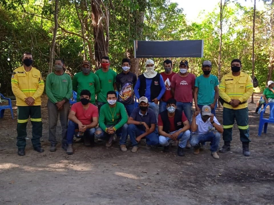
In 2019, the Krahô-Kanela people suffered a tragedy, when about 95% of their territory was consumed by fire. According to Wagner Katamy, the situation was very sad. The tragedy was not even worse because indigenous brigade members fought 22 kilometers of fire, which came within only 2 kilometers of the village. Javaé, Karajá and Xerente peoples’ brigades went to the Krahô-Kanela Indigenous Land to help fight the flames.
The Federal Brigades Program was set up in 2013 as a fire management experience that combines traditional indigenous knowledge with technical and financial support from federal agencies such as IBAMA and FUNAI[3]. The initiative has had a positive impact on communities, but the lack of investment is a hindrance. The Krahô-Kanela brigade has 13 active members, but only 8 are paid for their work. “Today we have four hired brigade members and another four receive support from IBAMA”, says Wagner Katamy, who also works in the brigade. In 2020, the national program suffered a 58% cut in revenue. Payments for hired brigade members, plus per diems, fell from R$23.7 million in 2019 to R$9.9 million in 2020, when Brazil recorded the highest number of fire outbreaks in ten years[4].
Despite indigenous peoples’ efforts to control the fires, President Jair Bolsonaro, at the 75th General Assembly of the United Nations in September 2020, stated that the fires in Brazil are set by “Indians and half-breeds (caboclos)”. Wagner Katamy disagrees. For him, it is people who only seek to exploit the land economically that are destroying it, such as ilegal miners, loggers, and ranchers.
Notes
See more here: Núcleo de Ecologias, Epistemologias e Promoção Emancipatória da Saúde (NEEPES) at the Escola Nacional de Saúde Pública Sergio Arouca (ENSP), Fundação Oswaldo Cruz (FIOCRUZ). Mapa de conflitos: Injustiça Ambiental e Saúde no Brasil. May 28, 2015. Available here. Accessed on: Sept. 25, 2022.
At the time, the state of Tocantins did not exist and was part of Goiás. Tocantins was created in 1988.
To read more about indigenous brigades in Tocantins, see “RESISTANCE AGAINST FIRES: Traditional knowledge among Tocantins indigenous brigades”.
Regarding budget cuts for the environment, see the article in this dossier: “Socio-environmental policies: from dismantling to the challenges of recovery”.
Nature subjected to a predatory market logic
The municipality of Lagoa da Confusão (TO) is located inside the Rio Formoso Project, launched in 1979 as part of a process to extend Brazil’s agricultural frontier during the Brazilian military dictatorship[5].
Hydromorphic soils in floodplains enabled one of the world’s largest irrigated agriculture systems there to produce grains, mainly rice, corn and soybeans, and fruits like watermelons. The government of Goiás was responsible for the project’s initial technical study and implementation. Later, its management was transferred from the public sector to private initiative.
According to the Institute of Attention to Cities, at the Federal University of Tocantins[6], there are 98 hydraulic pumps in operation along the Formoso river, supplying water to large agro-hydrobusiness producers. Each of them, according to the institute, has the capacity to pump, on average, 96,000 liters of water per minute. Operating 24 hours a day, that means more than 138 million liters withdrawn per day.


To grasp the project’s socio-environmental impact, just one of those farmers’ pumps could supply the entire city of Palmas, the capital of Tocantins, with more than 306,000 residents. The pumping station that supplies 70% of the city draws 48,000 liters of water per minute from the river. In 24 hours, that is more than 69 million liters, just half of what a single farmer’s pump removes.
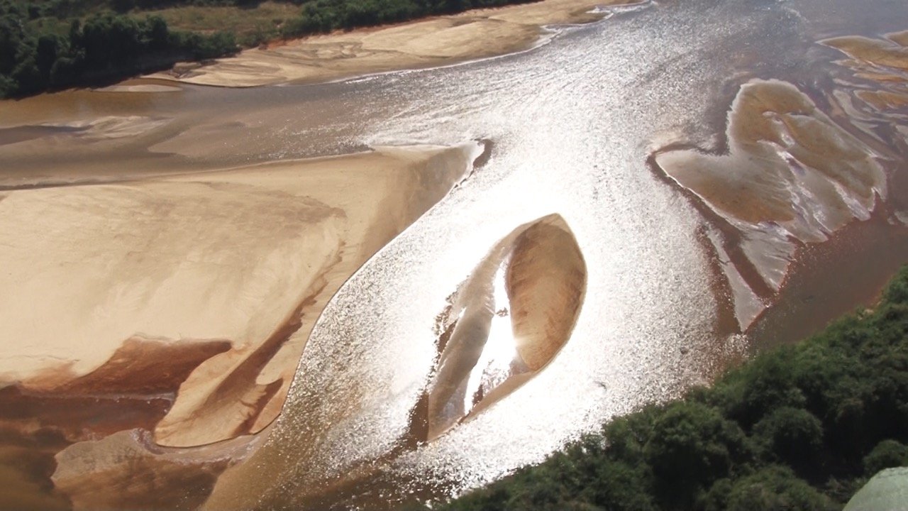
Today the region’s degradation is visible and notorious. Indiscriminate use of water on farms has altered the flow of rivers, destroyed riparian forests, and drastically reduced fauna such as fish and wild animals. According to indigenous leader Sebastião Krahô-Kanela, in a report to CIMI, local creeks where communities fished for food in the summer have dried up.
During the dry season, the Formoso, Javaés, and Urubu riverbeds fill with sandbanks due to the drastic reduction in the volume of water. In some stretches, one can wade across the river. In the region since 1954, Chief Valdete Ribeiro da Costa, of the Krahô-Takaywrá people, said in a statement to CIMI that today there are places he no longer recognizes with so many ditches taking water from the river, whose beds have shifted, along with all the surrounding vegetation.
Not only the Krahô-Kanela are hurt by the Rio Formoso Project
The project has a series of main irrigation canals with smaller side canals bordering the existing plots. To maintain the water levels, three reservoirs were created: Taboca, Calumbi I and Calumbi II, which are now eroding and silting for lack of maintenance. The canals have no waterproofing, and the water runs in the open air, generating water loss through infiltration and high evaporation. Along the banks of the canal, mechanical openings of smaller and deeper ditches are made for the circulation of water, irregular works carried out with no environmental licenses or approval by the Nature Institute of Tocantins (Naturatins), the state environmental enforcement agency.
The region is home to one of Brazil’s most important ecological sanctuaries, in the transition between the Cerrado and the Amazon, which also has features and is influenced by the Pantanal’s rich socio-biodiversity. In the region there are species common to the Pantanal of Mato Grosso, such as the jaguar, porpoise, uirapuru birds and blue heron. There is a diversity of large fish, such as the piraíba, pirarara, dolphin, and pirarucu. Among the wild animals are turtles, alligators, pumas, monkeys, anteaters, armadillos, rheas, deer, and wolves, in addition to birds such as jabiru storks, teals, herons, kingfishers, and hawks. In the project region there are also threatened and endangered species, such as the Pantanal deer.
The project is located near the Bananal Island, an environmental preservation area and home to three indigenous lands (IL) with great ethnic and cultural diversity: the Iñawébohona (or Boto Velho) IL, the Parque do Araguaia IL, and the Utaria Wyhyna/Iròdu Iràna IL. They occupy part of the areas of three municipalities, Formoso do Araguaia, Lagoa da Confusão and Pium. In addition to the Krahô-Kanela people, the region is home to Javaé, Karajá, Avá-Canoeiro, Krahô-Takaywrá, and Kanela do Tocantins peoples, and also an indigenous people in voluntary isolation on Bananal Island. There is also a strong presence of peasant communities and family farmers.
Even living in a region rich in rivers, indigenous communities suffer from water shortages, especially from July to November. According to Wagner Katamy, from the Krahô-Kanela people, water is very important because it is life, and part of the indigenous peoples’ daily lives. They practice subsistence agriculture, traditional extractivism, hunting, and artisanal fishing. Crops are grown according to traditional practices, integrated with the dynamics of the waters, during the rainy season and when the rivers run low. They need living rivers and standing native vegetation, on which they depend to live and exist, and with which they develop unique relationships, full of cultural values.


Pesticides pollute the waters and poison people
Large plantations, besides consuming high volumes of water, use large amounts of chemical fertilizers and pesticides. In the Rio Formoso Project area, the poisons contaminate the soil, water, and fauna. Often, they are sprayed by airplanes and carried by the wind into local communities. Herbicides are applied directly on the water in irrigation canals to control water lilies. At rice harvest time, the water is pumped from the fields back into the river, along with all the pesticides used, contaminating the fish and the water consumed by communities, with negative effects on people’s health.
According to official data from the Ministry of Health’s Information System for Surveillance of Water Quality for Human Consumption (SISAGUA), from 2014 to 2017, 27 pesticides were found in the water that supplies the municipality of Formoso do Araguaia, one of those involved in the irrigation project[7]. Of those chemicals, 11 are associated with chronic diseases, such as cancer, birth defects, and endocrine disruptions. The riverside population remains invisible and voiceless in this process and suffers the consequences, such as more cancer cases, which have a negative impact on community dynamics. Pesticides also contaminate and interfere with the life cycle and reproduction of turtles, wild mammals, and birds.
MATOPIBA
As if the woes inflicted for decades by the Rio Formoso Project were not enough, several other government initiatives have been adopted over the past few years, increasing water insecurity and socio-environmental damages. In 2015, the federal government set up the Matopiba Agricultural Development Plan (PDA-MATOPIBA), proposing the expansion of agribusiness in 337 municipalities and an area of more than 73 million hectares in the states of Maranhão, Tocantins, Piauí and Bahia (the name MATOPIBA comes from the acronym of the first two letters in the name of each of these states)[8].
In the region, there are 28 indigenous lands, 865 agrarian reform settlement projects, and 34 quilombola (descended from enslaved people) territories. The existence of residents in the region was ignored and their territories were considered uninhabited spaces, open to the expansion of agribusiness, thus increasing the concentration of land ownership and further threatening communities. This same unsustainable development model continues to expand, by voraciously devastating ecosystems and the wellbeing of communities, and forcing thousands of people into extreme poverty.
Notes
For further information on the Rio Formoso Project, see: RODRIGUES, Daniel Bartkus. O Projeto Rio Formoso e a reprodução ampliada do capital no entorno da Ilha do Bananal: concentração da riqueza, exclusão e resistência. 2013, 146 f. Master’s Dissertation in Geography – Master’s Program in Geography, Universidade Federal do Tocantins, Porto Nacional, 2013.
See: INSTITUTO DE ATENÇÃO ÀS CIDADES; UNIVERSIDADE FEDERAL DO TOCANTINS. “Gestão de alto nível: plano do biênio 2018-2019”, Palmas, 2017; and “Bacia do rio Formoso é a primeira totalmente monitorada no Brasil”. Instituto de Atenção às Cidades, 18 jun. 2018. Available here. Accessed on: Feb. 7, 2022.
ARANHA, Ana; ROCHA, Luana. “’Coquetel’ com 27 agrotóxicos foi achado na água de um em cada quatro municípios”. Repórter Brasil, 15 abr. 2019. Available here. Accessed on: Feb. 14, 2022.
Eliane Franco Martins and Laudovina Pereira are members of the Indigenist Missionary Council (CIMI), in the Goiás-Tocantins Region.